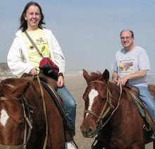

Then we went to Pomponio Beach just south of San Francisco for our first look at the Pacific Ocean. We have seen the Gulf of Mexico and now the Pacific Ocean on our travels, now we just need to get to the Atlantic Coast sometime on a future vacation.


We walked up a trail to the top of a nearby sand cliff that you can see in this photo for an aerial view of the Pomponio Beach and Pacific Ocean.

Here is the view from the top. Patty and Karen at the top.


We made another stop at Bean Hollow State Beach to hike along the nature trails and to photograph the waves and the rocks. The gull is a Western Gull, much larger than the gulls we see on Georgian Bay, could be twice the size.


50 miles South of San Francisco we stopped for a visit at The Pigeon Point Lighthouse. It is one of the tallest Lighthouses in the area, perched high on the rocky shoreline.


We stopped in Pescadero CA for a wonderful lunch at Duarte’s Tavern. For dessert Karen and Patty had the Olallieberry Pie and I stuck to the more traditional Strawberry Rhubarb Pie with ice cream.


Here is a view of the Pacific Ocean from high atop a hill just North of Pescadero CA. The first photo is not zoomed in to give you a perspective of the distance and altitude we are at, the second and third photo I zoomed in a bit for a closer look.


We are now heading North along the Pacific Coastline to Montara CA in search of the Montara Lighthouse. And we found it. If the Pigeon Point Lighthouse is one of the tallest, this one is definitely one of the shortest. I suppose because these Pacific Coast lighthouses are perched so high on the rocky cliffs along the shore, that it is not important that the actual structures be tall.

I experimented with stitching some photos together to create a panoramic view and it turned out to be a pretty good photo.

After a long day of walking around light house stations, it was time to head back to San Francisco for some ice cream. We stopped at Mitchell’s one of the well known ice cream stores in the city.
Karen enjoyed a peach ice cream. Patty also had peach and I had chocolate.


As you can see in these photos, we are not dressed in shorts and t-shirts.. we are finding it chilly in San Francisco. Day time highs are only 18 C and it is damp because of the constant fog. A few miles away from the coast and the fog dissapears and it is warmer, but anywhere near the Golden Gate Bridge, and you are pretty much guaranteed fog all day. July and August are not the best times to come to San Francisco for clear photos of the bridge. Next time we come it will be in September or October, no damp chilly fog then.
Patty drove us up to the top of Twin Peaks to see a 360 degree view of the city of San Francisco. Fog blocked most of the view, but I did get a few good shots.


To see all of our photos from today you can check out my FLICKR site.
Tomorrow we are heading North, across The Golden Gate Bridge and as far north as Bodega Bay CA.


No comments:
Post a Comment