
Here is a map of our route today.

We left Seaside Oregon and are heading inland now towards Multnomah Falls in Bridal Veil OR. The falls are 620 feet tall, compared to Niagara Falls at only 182 feet. What Multnomah Falls lack in water volume going over the falls, they make up for in height, creating a spectacular fall of water as it cascades down to a lower set of falls and then down to the Columbia River.


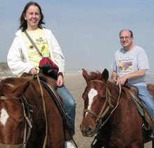
I never realized till just now, looking at my photo how much weight I have been packing on while on this vacation. When I get home, I will have to start to diet.


You can see the photos and videos of Mulnomah Falls on my FLICKR site.
We left Mulnomah Falls and headed North to Federal Way WA on Interstate 5. After driving on the Pacific Coastal Highway for the last 2 days, as much as I hate Interstates, it was a refreshing change to be able to use the cruise control for most of the drive today. My pedal foot certainly appreciated the break.
We got to add another State to our States Visited Map when we crossed the border from Oregon into Washington.

Tomorrow when we wake up we will have breakfast and then head for the Pier in Seattle to board our cruise ship for a one week cruise to Alaska.
I will try to post the blog each day while we are aboard the ship, but the Flickr photos will not be published till we get off the ship. There is a 50 cent per minute charge for an internet connection while onboard and it takes 1-2 hours each day to add the photos to Flickr, so once we get off the ship, I will have to get busy and upload all of the photos we take while on the cruise.
To see all of our photos from today, you can click on this link to my FLICKR site.

No comments:
Post a Comment